Ibiza is a magical island of luxuriousness, culture and spectacular scenery. It has all the ingredients for relaxing holiday, yet the island was sold short by its reputation as a hedonistic playground for clubbers and package tourists for many years. Those who are familiar with the White Island have always known about its pine-covered mountains, secret coves and tranquil villages, but now the rest of the world does too. In recent years, Ibiza has emerged as one of the most celebrated hangouts for jetsetters thanks to various factors. Ibiza’s recent rebranding as a luxury destination has put the charming Balearic Island on the map for luxury travellers. But what exactly are the key factors that have led to the island’s luxury revolution and iterate the necessity of a villa rental holiday in Ibiza in 2017?
1.World-Famous Party Scene
Showing posts with label Traveling. Show all posts
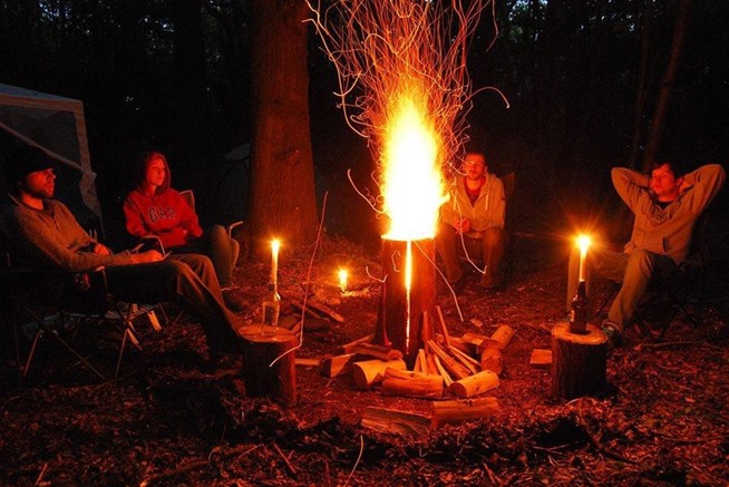
How to Make an All-Night Campfire with Just One Log (VIDEO)
This simple hack will allow a single log to burn for hours upon hours.Said to be created by an early train hopper to stay warm in between jumping trains.
It is called ‘The Swedish Torch’ and it is absolutely brilliant.
In the video below, YouTube user Doogly demonstrates how to make a Swedish torch, which is also known as Swedish candle, Canadian candle, Swedish fire torch, Swedish log stove, or similar name, using a chainsaw. Basically, instead of tossing any firewood into your fire pit, grab one thick log and make two cuts. These cuts should be deep, at least halfway through the log, and should form an X on the top.
These Are Good for Campfires & Cookouts
Once you've lit your newly cut log, you have a long-lasting fire that will keep burning until you're ready to hit your tent. Yet this fire building technique offers more options than simply warmth and light—it also provides a ready-made stovetop for your camp cooking.
It is called ‘The Swedish Torch’ and it is absolutely brilliant.
image via lowgravityascents
Once you've lit your newly cut log, you have a long-lasting fire that will keep burning until you're ready to hit your tent. Yet this fire building technique offers more options than simply warmth and light—it also provides a ready-made stovetop for your camp cooking.
If you simply want to relax around your campsite, seek woods like pine, fir, and birch. Weston calls these soft woods, which give off the scent and light of the traditional campfires we all love.
Image via Badgells Wood Camping
Different types of logs create different effects as they burn, and your choice may depend on the purpose of your campfire.
Mysterious Geoglyphs of Atacama Desert, Chile
The Atacama Desert, which stretches 600 miles (1,000 kilometers) from Peru's southern border into northern Chile. This massive, barren landscape consists of expansive salt flats, out of which towering volcanoes extend, reaching twenty thousand feet into the sky. The Atacama Desert is known to be the driest desert in the world, with a landscape resembling that of Mars.
The Atacama Desert is also famous for geoglyphs - sprawling, puzzling ancient artwork that are drawn into the landscape. Nearly 5,000 geoglyphs have been discovered in the Atacama in the last three decades. Scientists believes that these ancient artwork may be 2500 years old.The Atacama Geoglyphs are more numerous and widespread than their more famous counterparts at Nazca. They can be found in an area of over 100 square miles . They depict many subjects, Llamas and similar animals e.g. vicunas. Lizards, fish, birds, crosses, humans, chessboards and other geometric designs.
They can be found alone or in groups some as many as 65 geoglyphs. The smallest figure is about 1m tall and the largest the Atacama Giant 115m high. They are found near major trade routes in the area and like all geoglyphs can only be seen from the air.
In the specific focus of geoglyphs, there are two techniques by which they are created. The “extractive” technique, the more common of the two, involves scraping away the top layer of soil on the hillside, allowing for the soil beneath to create distinguishing designs on the surface. The “additive” process entails gathering materials such as rocks and piling them on the soil surface to create a raised outline. In the extractive process, the designs will appear lighter than the surrounding soil and in the additive process the designs will appear darker. There is also a third technique that is a complex combination of the additive and extractive processes which allows for a combination of light and dark colored figures .
Very less is known about the ways in which they may have been used in the past. The most recent research into the purposes of geoglyphs has revealed that many of the figures can be directly related to migration routes of the early desert peoples.
Source : cola.unh.edu
World's Largest Deserts (Top 10)
1. Sahara Desert, North Africa
The Sahara is the world’s largest desert. At over 9,000,000 square kilometers (3,500,000 sq mi), it covers most of Northern Africa, making it almost as large as the United States or the continent of Europe. The desert stretches from the Red Sea, including parts of the Mediterranean coasts, to the outskirts of the Atlantic Ocean. To the south, it is delimited by the Sahel: a belt of semi-arid tropical savanna that comprises the northern region of central and western Sub-Saharan Africa.
2. Arabian Desert, peninsula
Arabian Desert or Eastern Desert, c.86,000 sq mi (222,740 sq km), E Egypt, bordered by the Nile valley in the west and the Red Sea and the Gulf of Suez in the east. It extends along most of Egypt’s eastern border and merges into the Nubian Desert in the south. The Arabian Desert is sparsely populated; most of its inhabitants are based around wells and springs. Today most of the desert can be accessed by roads. Since ancient times Egypt has used the porphyry, granite, limestone, and sandstone found in the desert mountains as building materials. Oil is produced in the north. The name Arabian Desert is also commonly applied to the desert of the Arabian Peninsula.
3. Gobi Desert, Mongolia / N.E China
The Gobi is a large desert region in Asia. It covers parts of northern and northwestern China, and of southern Mongolia. The desert basins of the Gobi are bounded by the Altai Mountains and the grasslands and steppes of Mongolia on the north, by the Hexi Corridor and Tibetan Plateau to the southwest, and by the North China Plain to the southeast. The Gobi is made up of several distinct ecological and geographic regions based on variations in climate and topography. This desert is the fifth largest in the world. The Gobi is most notable in history as part of the great Mongol Empire, and as the location of several important cities along the Silk Road.
4. Kalahari Desert, Southern Africa
The Kalahari Desert is a large arid to semi-arid sandy area in Southern Africa extending 900,000 square kilometers (350,000 sq), covering much of Botswana and parts of Namibia and South Africa, as semi-desert, with huge tracts of excellent grazing after good rains. The Kalahari Desert is the southern part of Africa, and the geography is a portion of desert and a plateau. The Kalahari supports some animals and plants because most of it is not a true desert. There are small amounts of rainfall and the summer temperature is very high. It usually receives 3–7.5 inches (76–190 mm) of rain per year. The surrounding Kalahari Basin covers over 2,500,000 square kilometers (970,000 sq mi) extending farther into Botswana, Namibia and South Africa, and encroaching into parts of Angola, Zambia and Zimbabwe. The only permanent river, the Okavango, flows into a delta in the northwest, forming marshes that are rich in wildlife.
5. Patagonia Desert, Argentina
The Patagonian Desert, also known as the Patagonia Desert or the Patagonian Steppe, is the largest desert in America and is the 7th largest desert in the world by area, occupying 260,000 square miles (673,000 km). It is located primarily in Argentina with small parts in Chile and is bounded by the Andes, to its west, and the Atlantic Ocean to its east, in the region of Patagonia, southern Argentina. The Patagonian Desert is the largest continental landmass of the 40° parallel and is a large cold winter desert, where the temperature rarely exceeds 12°C and averages just 3°C. The region experiences about seven months of winter and five months of summer.
6. Great Victoria Desert, Australia
The Great Victoria Desert is a barren, arid, and sparsely populated desert ecoregion in southern Australia. It falls inside the states of South Australia and Western Australia and consists of many small sandhills, grasslands and salt lakes. It is over 700 kilometres (430 mi) wide (from west to east) and covers an area of 424,400 square kilometres (163,900 sq mi). The Western Australia Mallee shrub ecoregion lies to the west, the Little Sandy Desert to the northwest, the Gibson Desert and the Central Ranges xeric shrublands to the north, the Tirari and Sturt Stony deserts to the east, and the Nullarbor Plain to the south separates it from the Southern Ocean.
7. Great Basin Desert, USA
The Great Basin is the largest watershed of North America which does not drain to an ocean. Water within the Great Basin evaporates since outward flow is blocked. The basin extends into Mexico and covers most of Nevada and over half of Utah, as well as parts of California, Idaho, Oregon and Wyoming. The majority of the watershed is in the North American Desert ecoregion, but includes areas of the Forested Mountain and Mediterranean California ecoregions. The Great Basin includes several metropolitan areas and Shoshone Great Basin tribes. A wide variety of animals can be found in great basin desert. Look to the rocky slopes around the desert mountain ranges, you may spot a very rare desert bighorn sheep. Other mammals of the desert include kit fox, coyote, skunk, black-tailed jackrabbit, ground squirrels, kangaroo rat and many species of mice. Bird species are very diverse in desert oases.
8. Chihuahuan Desert, Mexico
The Chihuahuan Desert is a desert that straddles the U.S.-Mexico border in the central and northern portions of the Mexican Plateau, bordered on the west by the extensive Sierra Madre Occidental range, and overlaying northern portions of the east range, the Sierra Madre Oriental. On the U.S. side it occupies the valleys and basins of central and southern New Mexico, Texas west of the Pecos River and southeastern Arizona; south of the border, it covers the northern half of the Mexican state of Chihuahua, most of Coahuila, north-east portion of Durango, extreme northern portion of Zacatecas and small western portions of Nuevo León. It has an area of about 140,000 square miles. It is the third largest desert of the Western Hemisphere and is second largest in North America, after the Great Basin Desert.
9. Great Sandy Desert, Australia
The Great Sandy Desert is a 360,000 km2 (140,000 sq mi) expanse in northwestern Australia. Roughly the same size as Japan, it forms part of a larger desert area known as the Western Desert. The vast region of Western Australia is sparsely populated, without significant settlements. The Great Sandy Desert is a flat area between the rocky ranges of the Pilbara and the Kimberley. To the southeast is the Gibson Desert and to the east is the Tanami Desert. The Rudall River National Park and Lake Dora are located in the southwest while Lake Mackay is located in the southeast.
10. Kara-Kum Desert, Uzbekistan / Turkmenistan
The Karakum Desert, also spelled Kara-Kum and Gara Gum is a desert in Central Asia. It occupies about 70 percent, or 350,000 km², of the area of Turkmenistan. Covering much of present day Turkmenistan, the Karakum Desert lies east of the Caspian Sea, with the Aral Sea to the north and the Amu Darya river and the Kyzyl Kum desert to the northeast. In modern times, with the shrinking of the Aral Sea, the extended “Aral Karakum” has appeared on the former seabed, with an estimated area of 15,440 sq. The sands of the Aral Karakum are made up of a salt-marsh consisting of finely-dispersed evaporites and remnants of alkaline mineral deposits, washed into the basin from irrigated fields. The dusts blown on a powerful east-west airstream carry pesticide residues that have been found in the blood of penguins in Antarctica.
World's Worst Floods (Top 10)
1. Huang He (Yellow) River flood, China - 1931
The 1931 Central China floods or the Central China floods of 1931 are a series of floods that occurred during the Nanjing decade in the Republic of China era. It is generally considered the deadliest natural disaster ever recorded , and almost certainly the deadliest of the 20th century (when pandemics are discounted) and in China. The human casualties are estimated from lows of 400,000 to highs of 3.7 million to 4 million.
2. Huang He (Yellow) River, China - 1887
The 1887 Yellow River flood was a devastating flood on the Yellow River (Huang He) in China. This river is prone to flooding due to the elevated nature of the river, running between dykes above the broad plains surrounding it. The flood that began in September 1887 devastated the area, killing some 900,000 people. It was one of the deadliest natural disasters ever recorded.
For centuries, the farmers living near the Yellow River had built dikes to contain the rising waters, caused by silt accumulation on the riverbed. In 1887, this rising riverbed, coupled with days of heavy rain, overcame the dikes on around 28th September, causing a massive flood. Since there is no international unit with which to measure a flood's strength it is usually classified by the extent of the damage done,depth of water left and number of casualties.
The waters of the Yellow River are generally thought to have broken through the dikes in Huayankou, near the city of Zhengzhou in Henan province. Owing to the low-lying plains near the area, the flood spread very quickly throughout Northern China, covering an estimated 50,000 square miles, swamping agricultural settlements and commercial centers. After the flood, two million were left homeless. The resulting pandemic and lack of basic essentials claimed as many lives as those lost directly by the flood itself.
3. Huang He (Yellow) River - China - 1938
The 1938 Yellow River flood was a flood created by the Nationalist Government in central China during the early stage of the Second Sino-Japanese War in an attempt to halt the rapid advance of the Japanese forces.
The floodwaters began pouring out from Huayuankou in the early morning on June 9, 1938. As a result, the course of the Yellow River was diverted southwards for nine years afterward, inundating 54,000 km² (21,000 square miles) of land in Henan, Anhui, and Jiangsu provinces. All in all, the flood waters took an estimated 500,000 lives. Note that this number includes casualty from floods in Northern China in the same year. Accurate records had not been maintained and the area was constantly being repopulated. Keep in mind that this estimation of casualties has yet to be completely confirmed by China's historical and military experts. No one is sure of the complete details of this incident. For instance, the causes of death have yet to be resolved as simple drowning, malaria, famine, fatigue, cyclones, or other unnatural form of death. This claim of 500,000 Chinese and Japanese lives is very vague and the issue of the actions of the locals near the Yellow River in relation to the flooding cycles of the 1930s is uncertain.
4. 1642 Kaifeng Flood
Kaifeng, a prefecture-level city in eastern Henan province, People's Republic of China, located along the southern bank of the Yellow River, was flooded during a siege in 1642 by the Ming Dynasty army and by the peasant rebels led by Li Zicheng with water from the Yellow River. Over 300,000 of the 378,000 residents of Kaifeng were killed by the flood and the ensuing peripheral disasters such as famine and plague.
The flood is sometimes referred to as a natural disaster due to the role of the Huang He river and is currently listed as the 7th deadliest natural disaster in history with a death toll of some 300,000.
The city was once the capital of China, but it did not experience the same population growth as its surrounding provinces and after this disaster the city was abandoned until 1662 when it was rebuilt under the rule of the celebrated Qing emperor Kangxi. It remained a rural backwater city of diminished importance thereafter and experienced several other less devastating floods. The flood brought an end to the "golden age" of the Jewish settlement of China, which is said to span from about 1300 to 1642. By the time of the flood the Jewish population of China had reached about 5,000, mostly in Kaifeng.
5. Ru River / Banqiao Dam collapse, China - 1975
This flood was caused by the collapse of the Banquia Dam, along with several others, following a heavy rain caused by a typhoon. It is the worst dam related collapse in history.
The resulting flood waters caused a large wave, which was 10 kilometers (6.2 mi) wide and 3–7 meters (9.8–23 ft) high in Suiping , to rush downwards into the plains below at nearly 50 kilometers per hour (31 mph), almost wipe out an area 55 kilometers (34 mi) long and 15 kilometers (9.3 mi) wide, and create temporary lakes as large as 12,000 square kilometers (4,600 sq mi). Seven county seats, namely Suiping, Xiping, Ru'nan, Pingyu, Xincai, Luohe, Linquan, were inundated, as were thousands of square kilometers of countryside and countless communities. Evacuation orders had not been fully delivered because of weather conditions and poor communications. Telegraphs failed, signal flares fired by Unit 34450 were misunderstood, telephones were rare, and some messengers were caught by the flood. While only 827 out of 6,000 people died in the evacuated community of Shahedian just below Banqiao Dam, half of a total of 36,000 people died in the unevacuated Wencheng commune of Suipin County next to Shahedian, and the Daowencheng Commune was wiped from the map, killing all 9,600 citizens. Although a large number of people were reported lost at first, many of them returned home later. Tens of thousands of them were carried by the water to downriver provinces and many others fled from their homes. It has been reported that around 90,000 - 230,000 people were killed as a result of the dam breaking.
6. Yangtze River, China - 1931
Although the Huang He has caused more deaths, the Yangtze has had more than 1,000 recorded floods.The worst period was from July to August. In July alone, four weather stations along the Yangtze river reported rain totaling over 2 ft (0.61 m) for the month.The casualties of the Yangtze river drainage region reached 145,000 and affected 28.5 million.
7. The Netherlands and England - 1099
A combination of high tides and storms flooded the Thames and the Netherlands, killing ~100,000.
8. St. Lucia's Flood, Netherland - 1287
St. Lucia's flood was a storm tide that affected the Netherlands and Northern Germany on December 14, 1287 (the day after St. Lucia Day) when a dike broke during a storm, killing approximately 50,000 to 80,000 people in the fifth largest flood in recorded history. Much land was permanently flooded in what is now the Waddenzee and IJsselmeer. It especially affected the north of the Netherlands, particularly Friesland. The city of Griend was almost completely destroyed, only ten houses were left standing. The name Zuiderzee dates from this event, as the water had merely been a shallow inland lake when the first dikesNorth Sea levels created the "Southern Sea" when floods including this flood came in.
Although not known by the name of St Lucia, the same storm also had devastating effects on the other side of the water in England. The city of Winchelsea on Romney Marsh was destroyed (later rebuilt on higher ground). Nearby Broomhill was also destroyed. The course of the nearby river Rother was diverted away from New Romney, which was left a mile from the coast, ending its role as a port. The Rother ran instead to sea at Rye, prompting its rise as a port. A cliff collapsed at Hastings, blocking the harbour and ending its role as a trade centre, though it continued as a centre for fishing. Parts of Norfolk were flooded, eg the village of Hickling where 180 died and the water rose a foot above the high alter in the church. The port of Dunwich in Suffolk began its decline. Winchelsea in Kent also reported to have been hit by the surge.
9. The Neva River, Russia 1824
The largest flood occurred on November 19 1824, when the river reached 13.5 feet (410 centimeters) over the usual level. On that day most of the city was flooded, between 208 and 569 people were drowned and 462 houses were destroyed. The second severest flood (over 12 feet high) was in 1924. In some areas of the city the water flowed to a height of 7-8 feet and many of the ships in the port were washed ashore. Approximately 1000 people killed in this flood.
10. St. Elizabeth's flood, Netherland - 1421
The St. Elizabeth's flood of 1421 was a flooding of an area in what is now the Netherlands. It takes its name from the feast day of Saint Elisabeth of Hungary which was formerly November 19.
During the night of November 18 to November 19, 1421 a heavy storm near the North Sea coast caused the dikes to break in a number of places and the lower lying polder land was flooded. A number of villages were swallowed by the flood and were lost, causing between 1,000 and 10,000 casualties. The dike breaks and floods caused widespread devastation in Zeeland and Holland. This flood separated the cities of Geertruidenberg and Dordrecht which had previously fought against each other during the Hook and Cod (civil) wars.
Most of the area remained flooded for several decades. Reclaimed parts are the Island of Dordrecht, the Hoeksche Waard island, and north-western North Brabant (around Geertruidenberg). Most of the Biesbosch area has been flooded since.
The cause of the flood was not a spring tide like in the great flood of 1953, but water from the storm in the North Sea surged up the rivers causing the dikes to overflow and break through.
The Elephant Rock, Iceland
The Elephant Rock is volcanic basalt sea-cliff on the island of Heimaey in Southern Iceland that resembles a giant elephant or wooly mammoth dipping its trunk into the sea. This is found in Vestmannaeyjar Archipelago town residing nearly 4,500 residents in an area of 5.2 square miles. Despite of this small amount of population, it is still considered as one of the most populated island of the location.
Image credit: Diego Delso
The major reason behind formation of this Elephant rock is 660 ft. high active volcano named Eldfell (Mountain of fire). The volcanic eruption happens occasionally without any prior alarming activity and the inhabitants have to rely on sea water for cooling down the erupting lava. Due to these activities, various types of rock formations keeps happening around the location.
Most Extreme Places on Planet Earth
Earth has undoubtedly many beautiful places. You can come across the nicest landscapes and spectacular sights all around the planet.
1:Aogashima, The Inhabited Volcanic Island of Japan
Aogashima is a volcanic island 3.5 km in length with a maximum width of 2.5 km, formed by the overlapping remnants of at least four submarine calderas. The island is surrounded by very steep rugged cliffs of layered volcanic deposits. The southern coast also rises to a sharp ridge forming one edge of a caldera named Ikenosawa with a diameter of 1.5 km. The caldera dominates the island, with one point on its southern ridge, Otonbu with a height of 423 metres (1,388 ft), as the island’s highest point. The caldera is occupied by a secondary cone named Maruyama.
Aogashima is a tropical volcanic island in the Philippine Sea, administered by Tokyo despite being located approximately 358 kilometres (222 mi) south of Tokyo. It is the southernmost and most isolated inhabited island of the Izu archipelago.
2:The highest point on Earth
Mount Everest, part of the Himalayan range in Nepal, is the highest peak above sea level with 8,848 metres. It usually takes climbers over a month to acclimatize before occupying arguably the most extreme of the most extreme places on Earth.
3:Venezuela Angel Falls
It is the world's highest uninterrupted waterfall, with a height of 979 metres (3,212 ft) and a plunge of 807 metres (2,648 ft). The waterfall drops over the edge of the Auyantepui mountain in the Canaima National Park (Spanish: Parque Nacional Canaima), a UNESCO World Heritage site in the Gran Sabana region of Bolívar State.
4:Badwater Basin in Death Valley National Park, the lowest spot in North America.
For the record, the Dead Sea, between Israel and Jordan, is the lowest spot on Earth at 1,371 feet (418 m) below sea level.Badwater Basin, in Death Valley National Park, is the lowest place in North America and one of the lowest places in the world at 282 feet (86 m) below sea level. This elevation is the result of geological forces that began stretching the western margin of North America about 16 million years ago and eventually deformed the Death Valley area into an alternating series of trough-like basins and towering ranges.
5:Krubera Cave
The Krubera Cave is the deepest known cave on Earth, -2.191 metres. It is located in the Arabika Massif of the Gagrinsky Range of the Western Caucasus, in the Gagra district of Abkhazia, north-west of Georgia.
The Most Outrageous Before and After Photos You Have EVER Seen
Before and after photos are the best. They are ageless proofs of certain changes, and the bigger those changes are, the more excited we all get about them! The thing is, we all change, all the time. Even our cells are dying and being replaced all the time, which means that we change from the within too, even though these changes are not as visible. However, there are some changes that are more visible than others, and we’re not only speaking about people and their faces! These changes are actually so visible, and they happened so many times throughout the history, they are even shocking sometimes! That’s exactly why we decided to make a list of the most outrageous before and after photos you’ve ever seen.
1. Wow! Dubai has certainly gone a long way from being a small, desert city to being the most expensive city in the Middle East. By the 1960, Dubai’s economy was mostly based on trade. However, ever since oil was discovered, the most populous city in the United Arab Emirates accelerated its development. Today, Dubai is the center of tourism, real estate, financial services and it is definitely iconic for its skyscrapers and infrastructure. Naturally, before and after photos of Dubai are fascinating.
2. For the last four years, California has been going through an extreme drought. The severe drought has left California’s valley fields and lakes bare and dry, and as farmers watch their crops die, the water supplies have been in shortage as well. Warnings have been issued and water-wasters are facing fines up to $10,000, but still, the environment has changed a lot, and residents of the most affected cities need to adjust their lifestyles to new conditions. One of the “victims” is Lake Oroville.
3. New York went through one of the biggest transformations in the history of the city from the early 1980’s until the 2000’s. The rebirth of Wall Street during the 1980’s made New York the center of the worldwide financial industry. This trend remained through the late 1990’s, when the city benefited from the success of the financial sectors, such as Silicon Alley. Naturally, the financial growth was followed by more buildings and generally, big changes in the city’s infrastructure. This before and after photo of Times Square shows the change that lasted for 30 years.
1. Wow! Dubai has certainly gone a long way from being a small, desert city to being the most expensive city in the Middle East. By the 1960, Dubai’s economy was mostly based on trade. However, ever since oil was discovered, the most populous city in the United Arab Emirates accelerated its development. Today, Dubai is the center of tourism, real estate, financial services and it is definitely iconic for its skyscrapers and infrastructure. Naturally, before and after photos of Dubai are fascinating.
Source: www.sacramento.cbslocal.com
2. For the last four years, California has been going through an extreme drought. The severe drought has left California’s valley fields and lakes bare and dry, and as farmers watch their crops die, the water supplies have been in shortage as well. Warnings have been issued and water-wasters are facing fines up to $10,000, but still, the environment has changed a lot, and residents of the most affected cities need to adjust their lifestyles to new conditions. One of the “victims” is Lake Oroville.
Source: www.imgur.com
4. Christian Bale is definitely one of the most popular, but also, iconic movie stars in Hollywood. He is also the living proof that actors sacrifice a lot if they want to show the world how serious they are about their career. Christian proved many times that he is physically ready to change himself for the role- and he did it successfully every single time. Over and over again, Christian shocked us with his incredible weight loss or weight gain and obviously, with his before and after photos.
Jeep Tour Guides… How To Get Hired And What To Expect If You Pursue This Career Choice
Ever wonder what it’s like to be a Jeep tour guide?
Arguably, Sedona, Arizona is the Jeep tour capital of the world. With the great weather, gorgeous scenery, and easy access to a myriad of trails, no wonder there are so many tour companies.
I’m a Jeep tour guide in Sedona, and many people think that this would be a dream job. If you are one of those, read this first!
Here’s everything you want to know about Jeep tour guides, including how to get hired and what to expect your first days on the job.
Wanna Be A Jeep Tour Guide?
Many think it sounds like fun, and it is, for awhile. But, for most, the romance wears off quickly. The average career lifespan of a Jeep tour guide in Sedona is less than 2 years, but there are those who have been guiding for 5, 10, even 20 years.
I have been in the Jeep tour business since 1996, which makes me about 96 in Jeep years.
I have eaten enough red dust to be convicted of smuggling federal property.
I have ushered thousands of visitors into the backcountry.
I have grown tired of the sound of my own voice.
I have watched Jeeps go from the showroom floor… to tour status… to beyond reasonable maintenance and relegated to the Jeep retirement lot with 150,000 trail miles on them.
I have hosed off various types of excrement from Jeeps.
And I have seen guides in training, passed by them on the trail for awhile, then saw them eventually move on to a “real” job.
Let me give you some insight to the whole world of professional Jeep tour guiding, from start to — finish.
First of all, it takes a certain type of person to really be a guide, as an ongoing career. Most “career” guides are very serious nature and history lovers. They drive Jeeps all week, then spend their days off hiking, biking, or even Jeeping. They love to read. They have heated debates with their associates about the current scientific name of the javelina, the best way to eat agave, or the latest tour joke. They are clever, independent, resourceful, animated, and loud. They are very much people-people — they love to entertain and be the center of attention. And they can deal with a great deal of ups and downs, not just on the trail, but also in their schedules and bank accounts.
Man spent 9 years being trapped on the island is now rescued because of Google Earth !
If you have ever watched the movie, Cast Away, you would know that how Tom Hank spent long time on a deserted island. Here is a similar story about Adam Jones, who spent almost 9 years being trapped on a deserted island, but with the help of Google Earth, he was rescued recently! Here is how he spent 9 years there!
The Voyage
Adam Jones set off for a journey in 2006, along with his 2 friends, starting from Liverpool, their home, to Hawaii. In between they had to cross Atlantic Ocean and the Panama Canal. As they reached in the middle of the Pacific Ocean, a monstrous storm struck their boat violently, and damaged it along with their electronic equipment. His friends went overboard while Adam was knocked by the storm unconscious for about 17 days, and he kept drifting in the ocean.
Surviving the days in the beginning!
Adam spent 2 weeks on his boat but he built on his own the water trapping contrivance on it, and this way he saved a lot of water whenever it rained. At first he built a makeshift shelter out of boat debris, but it was collapsed and then he made a solid shelter. Using a clam shell, he brought a tree down in the span of 11 weeks. He somehow learnt how to make fire, and hence light in the dark!
Hunting for food!
Adam obviously had to hunt animals on the island for his survival, and he also found 8 wild goats there, but he couldn’t hunt them without any weapon. He tried to hunt them with his own made bow and arrow, but in vain. Fortunately he found a goat trapped in the bushes. After somehow killing it, he got 50 kg of meat from it.
He worked for his physical fitness!
Adam told that in order to stay fit, he used to do exercise daily on the beach, including push-ups, chin-ups using a tree branch, and he did squats having boulders over his shoulders. Also, he ran every day for about 300 meter on the beach.
The frustration and feeling of being lonely!
Adam said that the most difficult part of his survival was his fight with his brain. The feeling of being lonely, and the depression he felt whenever he thought that nobody would ever come to help, almost made him dead from inside. At first he made an SOS sign about 10 feet high, but no one came there. Then he decided to empty a large area on the beach and wrote there “SOS”. He always hoped that someday, some aircraft would fly form here and will see this sign and he will eventually be rescued. He couldn’t do anything except to have a strong hope and to never give up.
And there came the rescue team! FINALLY!
One day Adam heard loud noise of planes flying over him, he ran in the empty area and waved them, luckily they saw him and dropped a packet for Adam. The packet had a radio, fresh water, food, and some first-aid items in it. As he turned the radio on to talk to the pilot, he felt extremely happy to hear human voice after 9 years. He asked them how they reached there, they told him that a child living in Minnesota found his SOS sign on Google Earth and told the authorities that he was in need of help.
Even after being found, he waited for about 5 days because the boat took time to reach that island. Eventually, the lucky man was rescued from the unknown island on which he lived like a home for 9 years.
source
The Voyage
Adam Jones set off for a journey in 2006, along with his 2 friends, starting from Liverpool, their home, to Hawaii. In between they had to cross Atlantic Ocean and the Panama Canal. As they reached in the middle of the Pacific Ocean, a monstrous storm struck their boat violently, and damaged it along with their electronic equipment. His friends went overboard while Adam was knocked by the storm unconscious for about 17 days, and he kept drifting in the ocean.
Surviving the days in the beginning!
Adam spent 2 weeks on his boat but he built on his own the water trapping contrivance on it, and this way he saved a lot of water whenever it rained. At first he built a makeshift shelter out of boat debris, but it was collapsed and then he made a solid shelter. Using a clam shell, he brought a tree down in the span of 11 weeks. He somehow learnt how to make fire, and hence light in the dark!
Hunting for food!
Adam obviously had to hunt animals on the island for his survival, and he also found 8 wild goats there, but he couldn’t hunt them without any weapon. He tried to hunt them with his own made bow and arrow, but in vain. Fortunately he found a goat trapped in the bushes. After somehow killing it, he got 50 kg of meat from it.
He worked for his physical fitness!
Adam told that in order to stay fit, he used to do exercise daily on the beach, including push-ups, chin-ups using a tree branch, and he did squats having boulders over his shoulders. Also, he ran every day for about 300 meter on the beach.
The frustration and feeling of being lonely!
Adam said that the most difficult part of his survival was his fight with his brain. The feeling of being lonely, and the depression he felt whenever he thought that nobody would ever come to help, almost made him dead from inside. At first he made an SOS sign about 10 feet high, but no one came there. Then he decided to empty a large area on the beach and wrote there “SOS”. He always hoped that someday, some aircraft would fly form here and will see this sign and he will eventually be rescued. He couldn’t do anything except to have a strong hope and to never give up.
And there came the rescue team! FINALLY!
One day Adam heard loud noise of planes flying over him, he ran in the empty area and waved them, luckily they saw him and dropped a packet for Adam. The packet had a radio, fresh water, food, and some first-aid items in it. As he turned the radio on to talk to the pilot, he felt extremely happy to hear human voice after 9 years. He asked them how they reached there, they told him that a child living in Minnesota found his SOS sign on Google Earth and told the authorities that he was in need of help.
Even after being found, he waited for about 5 days because the boat took time to reach that island. Eventually, the lucky man was rescued from the unknown island on which he lived like a home for 9 years.
source
Cumberland Log Cabin Kit from $16,348
1.
While many people around the world are looking for a more sustainable form of building houses, there is a way that has been around for centuries that we can still use today! Take this gorgeous log cabin for example, this log home would be the perfect home for the whole family. The wonderful thing about log homes is that they have so many benefits over conventional dry wall homes.
2.
Log homes and cabins are very sustainable, as they are made from renewable materials that come from the Earth. Most of the logs used to build these log homes and cabins come from sustainable tree plantations, where the trees are used for their wood, and then more are planted in their place to grow into more trees for more logs. This is a better way of going about this process, rather than just chopping down any tree, so that we can keep the ancient growth forests alive, with their habitats thriving.
3.
Amish Cabin Company, is a log cabin kit building company that provides log cabin kits. The company works with their customers to provide a size and style of cabin that will suit the customer's needs and desires, and they have a phone line that you can call, so you can speak to someone directly on the phone.
4.
They provide all of the materials needed to build the log cabin that you purchase, and will be happy to help you with anything else you may need assistance with too. They also have a great and informative Frequently Asked Questions section that you can look at any time to answer any questions you may have.
5.
This particular home, The Cumberland Log Cabin, is a cozy and simple, log home. It features multiple bedrooms or office and a bedroom, and bathrooms. There is also potential for a beautiful deck to be built at the front of the home. It is perfect for a couple or a single family, or to use as a recreation property. You can also check out the other larger floor plans on their website. It could also be used as a rental unit on your property.
6.
Log homes are not only a great and sustainable home to buy, they are one of the most sturdy houses you can build. They are also very energy efficient, since the thermal mass of the logs is so high and they make wonderful insulators. The logs also act as air filters, filtering out some of the bad toxins in the air, which conventional homes don't do. Over all log homes are amazing and a wonderful choice of building that will last a lifetime!
Source : Cumberland Log Cabin Kit from $16,348
source
While many people around the world are looking for a more sustainable form of building houses, there is a way that has been around for centuries that we can still use today! Take this gorgeous log cabin for example, this log home would be the perfect home for the whole family. The wonderful thing about log homes is that they have so many benefits over conventional dry wall homes.
2.
Log homes and cabins are very sustainable, as they are made from renewable materials that come from the Earth. Most of the logs used to build these log homes and cabins come from sustainable tree plantations, where the trees are used for their wood, and then more are planted in their place to grow into more trees for more logs. This is a better way of going about this process, rather than just chopping down any tree, so that we can keep the ancient growth forests alive, with their habitats thriving.
3.
Amish Cabin Company, is a log cabin kit building company that provides log cabin kits. The company works with their customers to provide a size and style of cabin that will suit the customer's needs and desires, and they have a phone line that you can call, so you can speak to someone directly on the phone.
4.
They provide all of the materials needed to build the log cabin that you purchase, and will be happy to help you with anything else you may need assistance with too. They also have a great and informative Frequently Asked Questions section that you can look at any time to answer any questions you may have.
5.
This particular home, The Cumberland Log Cabin, is a cozy and simple, log home. It features multiple bedrooms or office and a bedroom, and bathrooms. There is also potential for a beautiful deck to be built at the front of the home. It is perfect for a couple or a single family, or to use as a recreation property. You can also check out the other larger floor plans on their website. It could also be used as a rental unit on your property.
6.
Log homes are not only a great and sustainable home to buy, they are one of the most sturdy houses you can build. They are also very energy efficient, since the thermal mass of the logs is so high and they make wonderful insulators. The logs also act as air filters, filtering out some of the bad toxins in the air, which conventional homes don't do. Over all log homes are amazing and a wonderful choice of building that will last a lifetime!
Source : Cumberland Log Cabin Kit from $16,348
source
Subscribe to:
Posts (Atom)
Ibiza’s Luxury Revolution: How the Island Transformed Itself
Ibiza is a magical island of luxuriousness, culture and spectacular scenery. It has all the ingredients for relaxing holiday, yet the island...
-
Hennessey Performance Engineering (HPE), Texas based tuner released the new photos of its heavily modified 705hp (526kW) version of the new ...
-
Hachiko was a real dog, he belonged to a Tokyo University professor named Eisaburo Ueno in the 1920’s. Hachiko is remembered for his remarka...
-
Year(s): 1971 A year after the Plymouth Valiant morphed into the sportier Duster, a new trim level was introduced called The Twister. This i...